Pages

Monday, July 7, 2014

Flagstaff and Palm Springs two very different cities!

Ancient Puebloan dwelling
It took us about three hours driving to reach Flagstaff from Monument Valley.  En route we stopped off at the Wupatki NationalMonument, which protects the ancient dwellings of Puebloan peoples.  Whilst having a look at one of the ruins we passed a woman who had collapsed due to the heat - the temperature was just over 100.  The park rangers were with her, but it was a stark reminder of the need to carry water even if only embarking on a short walk!  


The visitor centre housed information on the Native Americans, in particular the Navajo tribes.  An exhibition told how they had lost their land, which had arisen because, as an incentive to settle the west, railroad companies were granted ownership of huge tracts of public domain land along their routes. 


lava flow

Further into the park is the Sunset Crater Volcano National Monument, which features a 1,000 foot volcanic cone and its lava flows (the picture isn't great!)


Flagstaff is a charming town.   It is located on the original Route 66 and is about 75 miles from the Grand Canyon.  It is home to the Lowell Observatory, which is famous for confirming the existence of the planet Pluto.  With its high elevation (nearly 7,000 ft) the temperature was a pleasant 79 degrees when we arrived (it was the first time we had seen temperatures like this since leaving San Diego!) We spent a relaxing morning wandering the streets looking in all three of the huge walking stores there.  In the afternoon we visited the Museum of Northern Arizona, where we learnt more about the different Native American tribes in the area.  We also learnt that there are mountain lions roaming the area, which explains this road sign we saw in the Grand Canyon (I thought it referred to bobcats!)  We visited Walnut Canyon, but unfortunately they close the path at 4pm on the dot so we missed it by five minutes.   We were able to do the short rim walk and look at the cave dwellings far below us. 

We stayed in England House B&B.  Our hosts were wonderfully welcoming.  The gourmet breakfasts were amazing.  We had only intended to stay one night, but were seduced by Flagstaff so stayed for two.  We ate dinner in Carillo, a Latin restaurant where the food and wine was so good we decided to go there the following night too.   


PALM SPRINGS

Palm Springs is about a six hour drive from Flagstaff and two hours from San Diego so it made sense to spend our last night there.  Located in the middle of the desert, with its manicured lush green lawns, golf course and countless swimming pools it had to be seen to be believed.  Purpose built for pleasure, it couldn’t have been more different to Flagstaff!  It is surrounded by arid mountain peaks, which probably helps to protect it from the sprawl of further development.  Every Thursday evening there is a night market in downtown Palm Springs so we had a wander.  The temperature at night was still uncomfortably warm.  We ate a delicious meal at Ruben and Ozzy’s; while a soft spray of cooling water wafted over us (these cooling sprays are not good if your hair is of the frizzy type!)  It seemed wrong to be treating water in such a frivolous way, but we were told that water rates in Palm Springs are cheaper than in Oregon!  Palm Springs is located above a natural water basin, which may explain why water is in such a plentiful supply.  There was a lot more we could have explored, including a ride on the aerial tramway, but we were only there for a short time and the temperature was 115oF!  Thank goodness for the Desert Riviera Hotel – a quiet oasis. 

Friday, July 4, 2014

Monument Valley

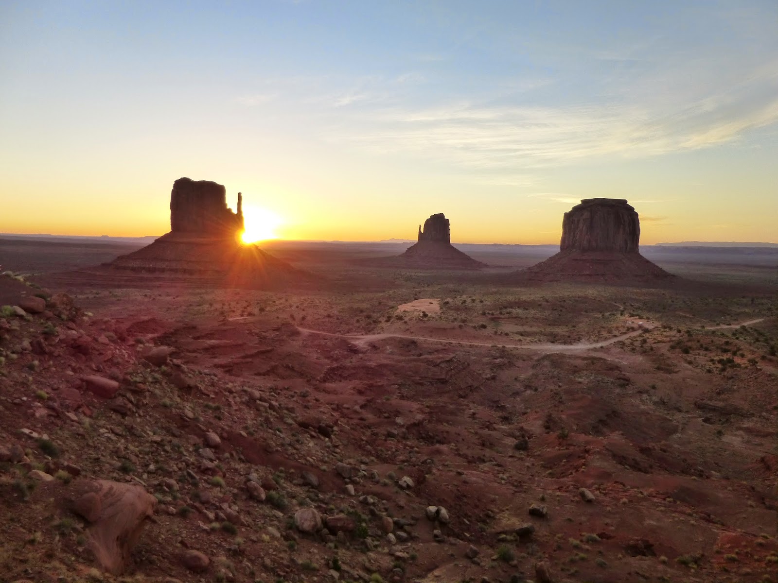
When I was growing up we watched a lot of cowboy films.  The scenery at Monument Valley is exactly as I’d imagined cowboy country.  It turns out a lot of films were made here in just five square miles.  The view is awe inspiring, the sandstone peaks and pinnacles (buttes) rising from the terracotta coloured valley floor up into the blue sky.  Occasionally the odd cloud would brush the tops of the buttes.  The terrain made me think how hard life must have been for the early settlers.  They only get six inches of rain a year here.


Monument Valley is just over the border from Arizona into Utah so there was a one hour time difference as Arizona has decided not to apply daylight saving time!  There is a 17 mile self-drive through the valley, but the track was rough and we were in the Mustang so didn’t dare embark on it.  The heat when we arrived was scorching so not a good time for walking.  Instead we sat on our balcony and drank in the view.  All the rooms at The View Hotel in the Navajo Tribal Park look out over Monument Valley.  It is one of the few options and the only one with a direct view of the valley.  It is owned and run by Native Americans so it provides employment meaning that people can stay close to their homeland and cling on to their culture.    


Every evening in the summer the hotel screens Wild West films that were made in the area, in an outside setting – John Wayne was showing when we were there – brought back many childhood memories! 
We sat and watched the sun going down – the buttresses and pinnacles taking turns to glow red and orange as the setting sun kissed them with its burning rays.  We slept with the curtain open so as not to miss sunrise, which seemed to begin at 4.30am.  The desert floor glowed as the sky turned from inky black to midnight blue.  The sun crept up peering above the first buttress before filling the valley with its glow. 

There is a four mile walking trail – the Wild Cat trail, but it was too hot to do it and we were in rattlesnake country.  If we had stayed for longer it would have been good to have gone out on horseback – the scenery really is suited to it.


Next stop was Flagstaff.  En route we stopped for lunch at Cameron Trading Post – the guacamole was delicious!  The ceiling of the restaurant was made of intricate moulded tin – we later learnt that as well as being decorative, tin ceilings are used to help stop fires spreading.  

Wednesday, July 2, 2014

Journey through Northern Arizona

Ten minutes from the green apple orchards of Julian we emerged into the blinding glare of the desert.    


The eight hour drive from Julian to the Grand Canyon was through a vast nothingness.  Much of it was along Route 78.  It wasn’t boring as the desert landscape was ever changing.  Just when you thought nothing could possibly survive in such a harsh environment you would arrive at a small town.  Weirdly there were lots of areas set up for camping cars parks or RV vehicles as they call them here – perhaps they are used in the winter months?  The temperature soared to 105oF!  A huge inland lake, the Salton Sea, twinkled in the distance like a mirage.  We could see an area of green in the distance. It stood out for miles against the otherwise parched terrain, which stretched towards the distant horizon.  It turned out to be fields of grass being cultivated for hay.  There were hay bales everywhere.  Then we saw the reason – an industrial cow farm. I have never seen so many cows crammed into such a limited space.   We were stopped at a police checkpoint – Richard asked the reason for the check and was told that it was because highway 78 ran close to the Mexican border. 

Finally, we climbed up out of the desolate plains.  As the we gained height, the temperature dropped to a more manageable 90oF.  The desert was soon forgotten as the road twisted through coniferous woods arriving at Prescott, a large town with manicured parks and a sense of purpose.   On the outskirts we passed ranches where the cattle roamed free.  Then, surprisingly, after this brief interlude, we were back out in the desert once again.  We drove through the town of Williams, on the original Route 66 and a popular stopping off point for the Grand Canyon as it’s only an hour away.  The town was overflowing with cheap motels, restaurants and tourists.

We were approaching the Grand Canyon from the south.  There were no clues as to what lay ahead.  I liked this surprise element.  It was $25 for a seven day pass to the National Park.   I sensed the Canyon long before I saw it, a breezy open abyss. Then I saw the pink hue of the rocks in the distance before the vista opened up.   Apparently most visitors only spend three to four hours visiting the Grand Canyon, so we were lucky as we were staying for three nights.  We stayed in the Yavapai Lodge complex.  It’s a mile away from Grand Canyon village and hence quieter.  A pleasant 15 minute walk through pine trees was all it took to get to the visitor centre and the rim (a shuttle bus also takes you there).


We embarked on the Southern Rim Trail and were pleased to have the path to ourselves for a lot of the time.  We were admiring the view (we did that a lot) when a condor soared through the air just in front of us – it was so close we could see its vivid red head.  Unfortunately I didn’t have my camera ready!  We had planned to do the walk in one day. However, although its an easy walk the heat got the better of us (they were having a heatwave) so we did the walk over two days.  Jet lag meant we were up in time to see the sunrise, although sunset was better.  On our last evening we walked to Shoshone Point – a quiet spot where we were able to watch the sun going down in solitary contemplation.  The Grand Canyon is a magical unforgettable place.


Thursday, June 26, 2014

California Dreaming

First impressions of San Diego were good.  The city is located on the shores of the Pacific ocean.  Everyone seemed relaxed and friendly.   But I only got a glimpse of the city as only there for the night. We had arranged to hire a car so that we can drive out to the Grand Canyon.  We've been given a bright red Mustang!!! 

We left San Diego and drove to La Jolla.  The beaches here are popular so the roads were busy.  I couldn't believe the number of cormorants, pelicans and seagulls  scattering the rocks and then on the boulders below were seals and sea lions sunning themselves completely unperturbed by the snorkelers and swimmers.

I was impressed by the chipmunk until I heard someone whispering 'look at that woman taking a photo of a squirrel!!' After having a truly tasty lunch in the Whisknladle restaurant we headed for Julian where we are staying tonight in the Eaglesnest B&B.  Julian is an old gold mining town and couldn't be more different to La Jolla!  We've stocked up on plenty of water ready for our traverse of the desert tomorrow - it's at least an 8 hour drive to the
Grand Canyon.


Sunday, June 15, 2014

A Walk With William

We last did this walk in April 2013  - see earlier blog post:-  

Then we were lucky enough to see our first otter in the Aveyron River.  No such luck today, although we did spot a deer in the woods at the start of the walk.  The climb uphill took us 45 minutes – we must be out of condition!  As we got to the top, we joined the GR36 on a broad track, where there is a beautiful view of Najac.  The track becomes a tarmac road as it goes through some houses (Le Bastit).  This is where we picked up William!  We tried to reason with him that we were going on a long walk, but he kept following us!  There are GR red and white flashes to mark the way.  After about 25 minutes you turn left at a junction – again it is signposted the GR36.  After 10 minutes you turn right on the Chemin des Enfants where the trees are festooned with toys.  Now there’s an idea for all those pre-loved toys!  
Continue on the path as it goes downhill over a stream and then through a conifer forest.  Ignore the first right fork uphill and keep going straight.  Take the next right fork still on the GR36.  Eventually you will arrive on the edge of Mergieux holiday village.  Since we did the walk last April Mergieux has closed and now looks rather forlorn.  The path now runs downhill to the river Aveyron.   Turn left (right follows the GR36 towards Laguepie).  


We stopped on our usual rock for our picnic – last April the river was so swollen our rock was submerged.   The rest of the walk was a nice easy one by the river back to Najac, the only obstacle being crossing the railway bridge – we had to improvise and so made the rucksack into a lead for William!   


The walk took us longer than usual (5 hours), probably because we sat and pondered along the way, absorbing the movement and life along the river.  And what about William? Well lucky for us he had a collar with his name and telephone number on so we took him home while we made the call.  Unlucky for us the telephone number didn’t work!  So we ended up driving him back to the spot he had joined us where he was reunited with the man who was looking after him – his owners are away.    We were sad to see him go.


Thursday, May 29, 2014

The Aveyron Valley Bowl

Najac stretched along the ridge
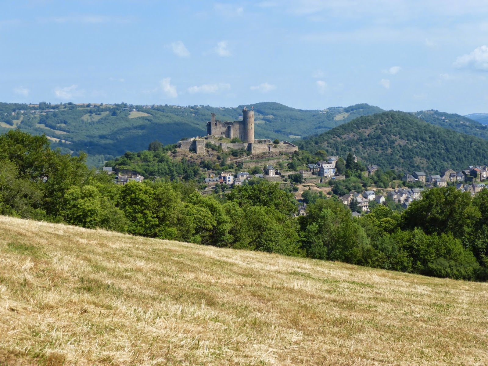
This weekend we stayed even closer to home – in fact the walk started from our front door!  We followed the yellow flashes of the local PR path.  It is a circular walk descending deep into the Aveyron valley to the river and then climbing back up over a rocky track to the hamlet of La Loubiere.   The walk is detailed in the Topo Guide – Les plus beaux villages de l’Aveyron a pied.  We chose the 9km circuit (walk no. 20).   It is one of my favourite local walks.   Much of it is along quiet roads.  The route takes you past La Singlarie where our friends run an organic farm.  For the most part, the walk rewards the walker with stunning views of Najac and its castle.  As we descended we spotted a bank of wild strawberries, which we feasted on (okay there weren't that many and they were tiny, but oh so tasty!) The climb back out of the valley gets your heart pumping, but it is worth it for the vast panorama when you reach the top.  Occasionally, on a clear winter’s day, you can see the snow-capped Pyrenees looming on the horizon. 
Lunch!


Wild flowers


Sunday, May 18, 2014

The Lot Valley

Last weekend we did a wonderful walk in the Lot valley.  It is from the book Au Coeur de la Vallée du Lot, Collection les belles balades de l’Aveyron : 22 balades à faire à pied, à cheval ou en VTT (walk number 14).  We’ve got several of these books and they have some beautiful walks in them as well as listing some interesting historical facts about the area.  They are of course in French.  The books are available from Tourist Offices.  This one cost about 6 Euros.    


12kms in length, the walk starts and finishes in the town of Bouillac.    The walk begins with an ascent (about 300 metres in total).  There are some perfect places for a picnic en route with sweeping vistas over the river and beyond.  After reaching the top, the path stays on the plateau for a while.  We were lucky to see a new-born calf take his first unsteady steps.   The path then descends over a rocky path towards a road – again the views were stunning.  The wild flowers that dotted the hillside gave splashes of colour.   There is a short stretch along the main road and then you cross a bridge over the river before taking a shady path on the right that runs next to the river over level ground.   After about an hour you take another bridge back over the river to Bouillac.  

Everywhere seemed shut, but then we spotted a bar that was open so we were able to reward ourselves with a cold beer.