Pages

Showing posts with label walking. Show all posts

Wednesday, February 27, 2019

Highlights of Oman - February 2019

February is the perfect time to go to Oman - the temperature is a steady 25 degrees and the sun shines every day! In our rental car we bumped along roads that would suddenly peter out or smart new highways where no one had got around to putting up signs for the exit roads. A lot of the time we guessed which direction to take and if we went wrong we would stop and ask someone. Without exception, the Omanis were friendly, helpful and welcoming. We met and made lovely new friends along the way.


There were so many positive experiences from our visit, but for me the turtles in Ras al Jinz remains the highlight. Such a privilege to watch these creatures haul themselves up the sand to lay their eggs on the same beach on which they were born. The reserve is run and protected by the government. Demand outstrips supply so rooms are often fully booked and come at a premium. There are also tents, which are even more expensive! But, an overnight stay includes two tours with a guide – the first one at night (very popular) and the second in the early hours of the morning (less popular probably because you have to get up at 4.30 am!)

Turtle Beach!

It wasn't the time of year for Green Turtles to lay their eggs so we were lucky to see one burying her eggs and another one actually laying her eggs - in fact, two popped out before my very eyes. No photography was allowed on the night tour as the lights from the flash confuse the baby turtles and cause the adults distress. The seashore was alight with phosphorescence - magical.

The morning tour was even better. We helped release baby turtles and watched as they wriggled to the water's edge and vanished into the waves. These little ones had got confused in the night, following the lights of the visitor centre, located about a kilometre away.

The guide led us to a turtle in her nest. At first, she was so still we feared she was dead, but our guide reassured us she was merely resting. It took over an hour for her to start to make her way back to the seashore.  As dawn broke she finally heaved herself from the nest. Deep ruts, like tyre tracks, marked the sand showing where she had crawled from the sea to lay her eggs over two hours before. She paused several times on her way before finally disappearing into the waves. It was an experience I'll never forget. 


There she goes!

Next on my list of highlights was the sight of camels roaming through the hills and desert. This one wasn’t the least bit photo shy! 


We didn’t go into The Sharqiya Sands desert, but we glimpsed the enticing orange dunes from the motorway. We were put off staying there by the huge resorts advertised in the guidebook. We’ve since been told of smaller outfits where you can stay with Bedouin families – definitely something on our agenda for a return visit! 

If only all the road signs were this clear!

Wadi Shab was lush and green with clear, almost turquoise water.  It was a beautiful but popular spot, although there weren’t many walkers who continued past the rock pools. 


Sur, located on a pretty part of the coast, had a laidback vibe and made for a relaxed stopover. They still build and repair Dhow boats here. There were hardly any tourists wandering the souk and curious children called out to us “hello, how are you," and before we could answer they would say, "I am fine, thank you." We ate at Zaki’s restaurant – the best Indian food we have eaten outside India! 


The mountains of the Western Hajar were stunning. Who would have thought that beauty could be found in such an arid landscape. The village of Misfat al Abryeen (Misfah), a group of ochre coloured houses huddled on a hillside above date palms, was beautiful. We stayed at the Hospitality Inn, a typical Omani guesthouse with mattresses on the floor, open communal terrace and shared bathrooms.


Staying here meant we were poised for a walk in the mountains (there aren’t many trekking maps, but the routing for the W9, which leaves the village was clearly signposted with splashes of paint marking the way). 

Walk W9
A Falaji
To stay in Misfah was like stepping back in time. Pathways twisted amongst ruined houses and through date palms. Occasionally a donkey would stumble past carrying a heavy load.  Its popularity with tourists is highlighted by the signs at the village entrance warning visitors to dress appropriately. Many of the six hundred-year-old crumbling mud-brick houses are being restored and one gets the feeling change is imminent. The hillside is terraced and criss-crossed with waterways or falaji, as they’re called. Life revolves around this important water source, which we were told never runs dry. Every available space is used for growing produce including, pomegranates, bananas and papaya. There are 25 different varieties of date palms here and we watched a man take a flower from the male date tree and deftly climb up a female tree to fertilise it with the flower. The modern village sits on the opposite side of the gorge, steadily expanding under the watchful gaze of its old neighbour. 

Misfah
We spent three nights in Nizwa. Our stay coincided with the famous Friday Goat Market in the souk. The event is popular with tourists and locals alike. People gather around a central area to watch the occasion. As well as goats, there are cows and occasionally one of them would break free to run through the crowds. They even had baby camels for sale! 


We also visited our only fort – there are a lot of forts in Oman, but the one in Nizwa is impressive and has lively cultural displays. 


Hide and seek, Omani style!
A wander around the ancient ruined village of Al Munisifeh was very atmospheric as we had the place to ourselves and were able to go inside the buildings to climb rickety staircases and admire the arches and doors that had endured. My obsession with Omani doors began here!  


Al Hamra is another ancient village of mud-brick houses, but here they have a living museum, which was interesting and we learnt about the Indigo trade.

Muscat, the capital, is a pleasant city. The buildings are low-rise, which was a surprise. The Grand Mosque, the only mosque in Oman open to non-Muslims, was incredible.  


We were only able to explore one small part of Oman and there remains so much more to discover, so we will have to go back!


Tuesday, September 11, 2018

Los Picos De Europa - September 2018

Years ago, as we sheltered from a thunderstorm in the Spanish Pyrenees, a fellow walker told us about the Picos De Europa. She said it was a paradise. So the seed was sown and last week we went – it was well worth the wait!
  

We approached the Picos from the city of Leon, where we had spent a couple of nights in an old monastery  Leon is on the Camino de Santiago pilgrim route. For me, the cathedral and pantheon were the highlights. The Gothic cathedral was built when the city had a population of only 5,000.  The ancient stained glass windows have retained their intense colours and cast an atmospheric glow over the interior.

From Leon, the Picos was a two hour scenic drive away. We stayed in comfort and luxury (very different to our normal mountain retreats) at Hotel Eigon in the village of Posada de Valdeon. The village sits in the centre of the valley hemmed in by mountains and feels very remote. On our first day we did a beautiful hike to the via ferrata – one look at the bridge suspended over a long drop, told us it wasn’t for us so we decided to save that experience for another day (or maybe never!) 

In the evening we ate at Casa Begona – a family run, inexpensive place with rustic food, eclectic decor and a very entertaining waiter.


The next day we walked the famous Cares Gorge, said to be one of the best hikes in the whole of Spain. The 22km walk (there and back) runs between Cain and Poncebos with a total ascent of 400m (100m there, 300m back).  It divides the central and western massifs, opening a pass between the high mountains. Starting from the village of Cain I wondered what all the fuss was about but as the path continued, wending its way through tunnels and limestone arches, we eventually emerged to a view of limestone crags against a cerulean sky and it was paradise. It is the combination of gorge walking and mountain walking that makes it special. 


Although the path is broad there is no protection at the edge from a drop of several hundred metres, but I have a good head for heights and never felt scared. The bad weather held off too, although we were a lot faster on our return journey as storm clouds threatened!


A long way down!


Sadly our third day in the Picos was stormy so we were forced to sample a carajillo or two and relax in the comfort of the Hotel Eigon and plan walks for our next visit!

Friday, April 6, 2018

Spring arrives in Le Midi!

Today we did a magnificent 15km walk in the Tarn et Garonne.  It was taken from the book 38 Randonees.  We parked the car at St Project and headed downhill on the main road to pick up a narrow track on the left (signposted with yellow Sentier Communale signs).  The chateau de la Reine Margot looked splendid against the clear blue sky. 


Chateau de la Reine Margot

For the most part the route was along beautiful shaded paths with only a little bit of road walking.  This time of year the fields looked lush and green (there has been a lot of rain) and the dandelions are growing well!  For the whole walk we didn’t see a soul, apart from a lady who passed us in her car with a cheery “belle promenade.”  And, for once, we didn’t get lost!    
 
Moss!


Thursday, September 15, 2016

Espot and The Aiguestortes National Park - Pyrenees

We arrived in Espot on a sunny Friday afternoon at the end of August. Espot is a pleasant, bustling town where locals and tourists mingle.   It is here that you take a 4x4 taxi into the Aiguestortes national park (you are not allowed to take your own car) – of course, you could walk the 8km up the road if you wished.  We stayed in the comfortable Apartments Les Picardes.  From our apartment we looked out at lovingly-tended allotments and up to the mountains.  Each evening we would wander back to the apartment passing old barns reeking of sheep and groups of elderly men and women chatting in the sun outside their ancient stone houses.      

Walk 1
  
Estany de Ratera
We took a taxi to Estany de St Maurici.  The lake is a popular destination and starting point for many walks.  It felt strange arriving in a taxi and I wondered where all the people being dropped off would go.  We began our assent up the track and the going was tough, made tougher by the fact that a taxi passed us on its way to the refuge d’Amitges, our destination, with six smiling passengers on board.  We stopped for a snack break  – it helped.  The air grew noticeably thinner.  We reached Estany de Ratera – a wilder, pretty lake with a waterfall.  


We left a lot of people behind at this point. Now the going got really tough and, as we plodded uphill, more 4x4s drove by, their tyres slipping on the rocky track, as they made their way to the refuge.  I got second wind at this point, especially when I glimpsed the refuge.  Refuge D’Amitiges is a great place with good facilities.  We ate our lunch there (melon chunks make great trekking food) and restocked with water.  Lunch tasted better due to the fact we had walked and I was pleased we hadn’t taken a taxi.  We continued up and the path grew narrower (impossible for 4X4s to make it this far) with stunning views of the lakes, which got better and better.


We arrived at Port de Ratera.  The original plan had been to climb Pic De Ratera, but time was short so we had to content ourselves with reaching the pass at 2,550 mtrs.  We took the GR11 (the long distance path that runs along the Pyrenees) – the sign close to the pass said 1.5 hours back to Estany de St Maurici – it’s wrong and should say 2.5 hours as the sign an hour along the path reads 1.5 hours!  It was a long slog down, but great scenery and we heard the high pitch warning cry of a Marmot – we didn’t spot him though.    


Walk 2

This walk was a recommendation from the friendly staff in the visitors’ centre in Espot.  Again, the starting point was Estany De St Maurici where we followed a track passing the refuge Ernest Mallafre and up to Monestero.  The scenery was spectacular as the path, which hugs a gurgling stream for most of the way, took us through meadows, woods and over boulders to arrive at Estany de Monestero where we sat and ate our lunch surrounded by high peaks.  We chatted to two Spanish walkers who were heading up to the pass and beyond.  It would have been nice to continue, but we were heading back down. 


Walk 3


Today storms were forecast, but the clouds didn’t look too ominous so we decided to head up to the mountains.  Again, the starting point was Estany De St Maurici, but the weekend crowds had departed and the lake was peaceful.  The path was mostly up, but after two days of walking I felt fairly fit.  It was another beautiful, walk with different scenery and we only saw a handful of people.  Estany de Subenuix at the top was stunning and deserted.  But we didn’t linger as it was becoming increasingly cloudy.  We were nearly down when the heavens opened, but a mountain ash provided good shelter from the rain.  We finished off the day with a walk to the cascade at Maurici, stopping to take in the view.  


On our way back to Espot the taxi driver pointed out a herd of deer.  We arrived in Espot at the same time as a thunderstorm.  It was a violent one with lots of thunder and lightning. We felt lucky to be safely indoors!   


Estany de St Maurici

Friday, July 29, 2016

Two Walks on The Causse

Last weekend we parked the car at the pretty village of Loze for a four hour circular walk.  It took us up onto the causse. Much of this area is owned by the military and we passed many signs warning us to keep out.  The walk should have been straightforward and, for the most part it was until we got distracted by a local cycling race close to the village of St Project.  So engrossed were we in encouraging the last rider (who incidentally did not seem impressed by our cries of “Aller, Aller”) we missed our path.  But this was ok as our water supply was getting low and we thought we would take a detour to stop at the chateau in St Project for refreshments.  No tea rooms here, but a small cabinet containing luke-warm fizzy drinks – but they did go down well, we were parched!  It was just as well we had stocked up on liquid, as several detours later we still hadn’t found the correct path.  In the end we decided to walk back along the road (D19) to Loze.  It proved to be the right decision as the afternoon had turned hot and the road was gloriously shady.


Mouillac PR1 – this was supposed to be a short walk of 5 kms.  The original route was out and back on the same path, but the parish council (or French equivalent) had re-routed the path and it was now a longer circular walk, which was good as I find circular walks more satisfying.  This was an area we had never visited before despite only being 30 minutes from home.  The book describes it as a magnificent wild walk and it lived up to this description.  It felt so remote and we had the path to ourselves.  The land on the causse is poor and scrubby and we imagined how hard it must have been for past inhabitants to scratch a living and survive on such rough terrain.  The walk was, for the most part, on shady paths through a pretty valley and around the village of Pech.  We passed various ancient water sources – a lifeline for these rural communities years ago.  It was necessary to take a short detour to see the church and windmill at Mouillac before retracing our footsteps to a path opposite the Maire to continue our journey.  Later, we found a forlorn bench in an overgrown field with a long forgotten basketball net – it felt surreal as if the world had ended without our knowing it.  Despite the sense of surrealism and remoteness it was only a short walk back to civilisation and the car.    


The walks were taken from this book


Thursday, April 14, 2016

Varen – PR2 Le Chemin de Cadies

Cowslips
An easy walk, made all the more easier by missing the path and thereby missing a couple of kilometres, which was a shame as we were enjoying ourselves.  The walk (if you do it properly) is 10kms in total and should take 3 hours.  It is a circular walk.  Parking in the car park by the school it is easy to pick out the PR2 signs.  It begins with a gradual climb up a road.  A lot of the walk is on roads, but these were quiet and the views stunning.  It seemed we had the countryside to ourselves – mind you it was Sunday lunchtime! The route goes past Les Jardins de Quercy.  We wanted to have a look around, but the gardens are closed until 13th May.  We picnicked sat on a dry stone wall overlooking the gardens.  It was a beautiful spring day and the fields were full of cowslips.  All too soon we could see the spire of the church at Varen and that’s when we realised we had missed the path!  Still it meant we spent a pleasant half hour sat in the sun by the river.  The walk was taken from 38 Randonees – Tarn &Garonne, which we bought from the library in Varen.


Tuesday, January 5, 2016

A Walk of Contrasts

Serra Segaria with Montgo in the distance
The instructions in the book were clear – head to the second square at the village of Benimeli for the start of the walk.  Having done two complete circuits of the village and tried our Spanish out on a young girl we were none the wiser as to where the walk started.  Luckily a local bar owner, seeing us for a second time, took pity on us and pointed out the route.  The walk followed an old mule track as it twisted its way up the hillside, through squat bushes of rosemary and lavender.  It was a steep ascent and we had 400 metres to climb.  We were heading for phone and aerial masts high on the ridge above us – ugly, but a necessity in this modern age.  I was amazed to arrive at a small car park and road, which was disappointing after all the effort.  Still, at least we had the satisfaction of arriving there on foot.  Soon we were overlooking the summit towers of the Serra Segaria.  This was the point where the book said we must turn back as to continue along the ridge needed climbing skills, so we sat for a while drinking in the view before retracing our steps. We followed the road downhill before picking up the path.  The northern side of the mountain was verdant, very different from the arid southern side.  Cutting through a col back to the southern side we saw the plain stretched out below us, a giant chequerboard of orange groves.  
Overlooking the coastal plain and rice-growing marshes

We headed back to the bar and rewarded ourselves with a Carajillo (strong coffee with brandy).  The bar tender seemed surprised to see us so soon - I’m guessing he thought we would get lost!  

Wednesday, December 30, 2015

The book must be wrong!

Today’s walk started in the town of Gata de Gorgos, which must be famous for basket-ware judging by the number of shops selling rattan products.  We seem to have adjusted to Spanish time so we didn’t start the walk until 1.30pm, which allowed us no spare time if we went wrong!  It was a 12km walk with a long haul up to just over 400 metres and then down again.  The walk took us over a dry riverbed and then through terraces of ancient olive groves.  The sound of barking dogs followed us, but it wasn’t long before we left it behind.  At one point the path bore no resemblance to the descriptions in the book and, as I said, we had no spare time for mistakes.  After much pondering and retracing of footsteps we decided to follow the main drag only realising at the end we had missed out one of the minor peaks, which was just as well as we didn’t get back until it was almost dark!  

Sunday, December 20, 2015

Five Miles From Home And Hopelessly Lost!

Magic mushrooms?
This weekend we visited the church at the small hamlet of Salvetat-des-Carts for a Concert de Noel.  The church was full and everyone sang with gusto.  There was mulled wine and cake afterwards.  Whilst parking the car we had noticed a footpath sign so we went back today to investigate.  We had the Najac IGN map, which showed a route past the church, down into the valley and which seemed to link back to the footpath we had seen.  I like a circular walk always hating retracing my footsteps.  Unfortunately the path soon petered out.  The views from here were so different from normal and we soon felt disorientated.  Several barbed wire fences and gates later we found ourselves on the wrong side of the fence in a field full of cows.  Not wanting to disturb them we spotted the road in the distance and decided to head for it.  This was easier said than done as we stumbled down slopes, through brambles and over and under barbed wire fences.  We even had to ford a stream, well we would have done if it hadn't been dry.  Eventually we stumbled onto the road looking like we had been dragged through a hedge backwards - well we had!  We followed the road uphill for half a mile where we were rewarded with a view of Najac - one that we had never seen before. And from there we took a well signed footpath back to Salvetat-des-Carts without having to climb over any more barbed wire fences.
The way was blocked!
Najac

Sunday, November 8, 2015

Castanet PR1


It is always special walking from our own front door.  We bought this book from the library at Varen and yesterday we did our first walk from it.  We were looking for a new walk we could do without getting in the car.


It was a beautiful day, more like summer than autumn so, we packed a picnic and headed up the Mazerolles footpath to join the route.  It is a three hour circular walk.  We were astounded to find that, although we thought we knew the area well, most of the walk was along footpaths new to us.  We stopped for lunch at the charming hamlet of La Piale.  We didn’t see a soul, apart from a lone hunter who assured us that it was safe to continue and, towards the end, about 30 motorcyclists!  This being France, we all respected each other’s enjoyment of the environment, which meant we didn’t get shot at or run over!  It was a delightful walk, enhanced by the golden autumn colours and the fact that we were on new territory.

On Pech Maurel the highest point at 504m
Lunch spot at La Piale

Thursday, September 10, 2015

From the Viaur to Cheval du Roi

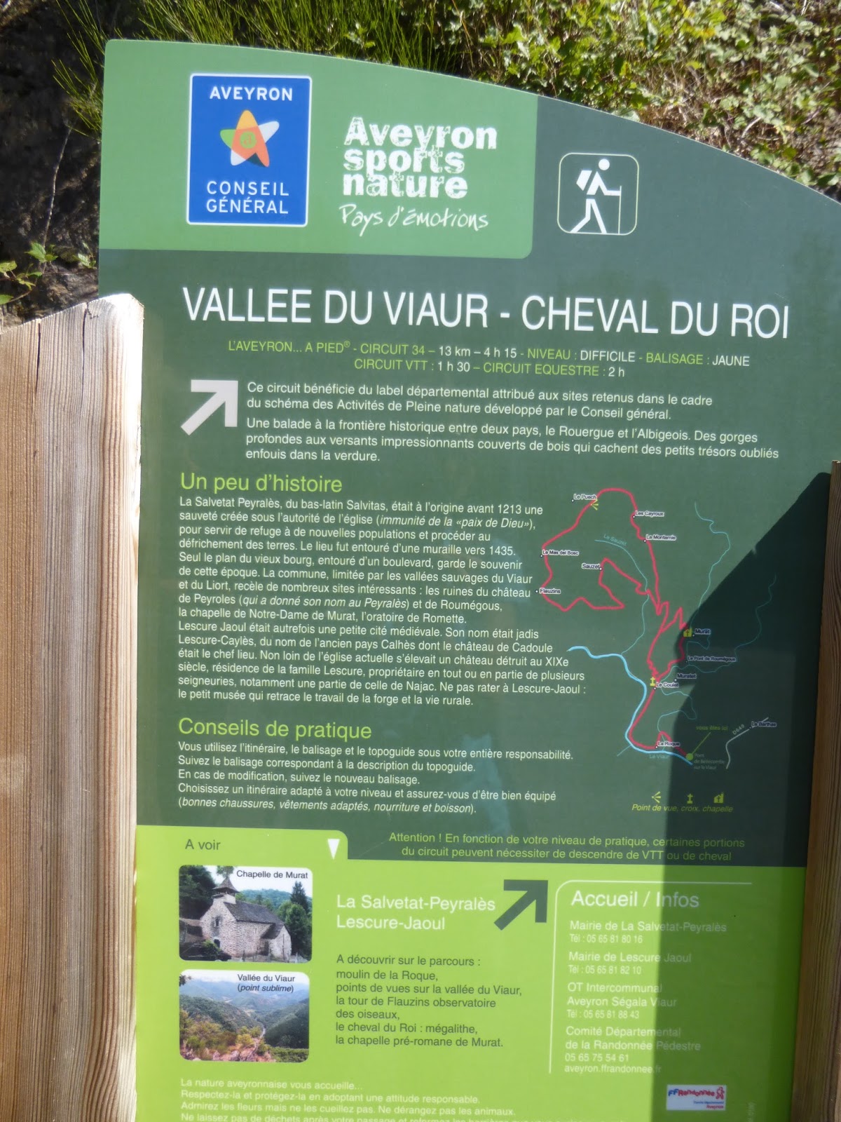
The walk was graded difficult in our walking book (walk no. PR34 in L'Aveyron a pied TopoGuides), probably due to an unrelenting climb of 1,200 feet.  It started at the valley bottom by the River Viaur and it was such a beautiful spot we decided to have lunch first.  Sitting with a picnic overlooking the river we saw the unmistakable iridescent blue of kingfishers streaking past.  We thought we knew this river so well, but this stretch was unfamiliar.  


The path followed the road for a bit, gradually climbing away from the river.  Then it was straight up via an old mule track.  We gained height fairly quickly, but even so it was a long slog uphill to reach the Cheval du Roi.  Some of the landmarks were familiar to us from when we took part in the Marche Gourmande at Lescure Jaoul (see blog post from July).  The villages on high looked desolate now with all the holiday homes shut up.  The scenery was breathtakingly beautiful, but hard to capture on camera.   

The path circled around the Cheval du Roi before heading back down.  A mistake where we turned left when we should have turned right ended with us being confronted by a couple of loose guard dogs – not a pleasant experience, but at least it forced us to turn back and thereby realise our mistake.  We should have turned right and walked behind an old chapel (Chapelle de Murat), but a parked truck was obscuring the sign (well that’s our excuse!)  There were sounds of work being carried out inside the chapel and Richard, spying someone, stopped to check we were going the right way.  The man invited us in to look at the chapel.  

Plaster was being chipped away inside by a group of volunteers to reveal ancient frescoes.  The volunteers were all from the troisieme age, French, except for an Irishman who joked that he was in charge of the wheelbarrow and just did as he was told.  They were so kind and welcoming even offering us a drink from their cool box.    It was interesting to learn some of the history of the Chapelle de Murat and that of the ruined Chateau de Roumegous, which stood above.  They expect the renovations to be completed next year and we promised to go back and see the finished result.  They posed for a couple of photos before waving us on our way.  It was only 30 minutes back to the car from here, but by now our feet were hurting.  
Chateau de Roumegous


When we got back to our picnic spot we were joined by a couple walking with a donkey.  They were obviously settling down to camp for the night so we left them to enjoy the last of the sun’s rays.  Another great day in and above the Viaur valley, a place we love so much.